One of the benefits of having regular walks is the ability to vary them depending on time and weather.
I set out from the lovely village of Glynde with the intention of returning via Alciston, thanks to a new walking book and new ideas as a consequence.
However, once I crossed the A27, a drizzly but mild day turned windier and windier. The clouds gathering above the Downs warned of possible rain to come so I made the decision to change my route. After following a lane for a mile or so, and seeing the state of the water-soaked fields on either side, this seemed an unusually wise choice.

Panoramic views worth the climb
Heading up to the Downs tested my resolve as the path got steeper and slippier, but I was rewarded with panoramic views on the way of the natural amphitheatre that is Ellman’s Combe and, once at the top of Glynde village, with the menacing Mount Caburn looming up behind it.
Once you reach the summit the path becomes the South Downs way and I decided to turn right, away from the twin radio towers and towards Southease and the English Channel. This section has to be one of the most barren but spectacular in the country. Newhaven shimmered through the mist, as the ferry bound for France rolled up and down across the choppy sea. By this stage it was freezing, and I regretted leaving my extra fleece at home but the path was firm and not at all muddy.
Southease Hostel and Cafe
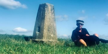
After a mile or two, passing a trigonometry point amidst possible burial mounds and some long-suffering sheep, the path began to slowly descend, with more stunning views across to Lewes and the river Ouse. Above the A26 the path descends sharply. On the day of my walk two enthusiasts were battling the gusty winds and flying model gliders that dipped and span wildly above me as I slipped and slided on the chalk Down to the bridge and across the main road for a welcome cup of tea at the YHA courtyard café.

Following the Ouse back to Lewes
During this break I decided to leave the second section of Downs above the village of Southease for another day and stroll along the Ouse instead. Crossing the Victorian swing bridge is a reminder that for centuries this area was no rural backwater but an industrial conduit between Lewes and the channel at Newhaven. This section of the walk is entirely flat, with views of the downs on both sides. I decided to begin on the raised banks and occasionally descended when the ground got too muddy.
The farmland between Southease and Lewes was considerably flooded and is a site of special scientific interest, forming the Lewes Brooks. I passed a bird watcher and one cyclist but otherwise all was quiet as the river wound round towards Lewes. Nearer the town I took the left-hand route to avoid the mud and skirted the large sixth form college and Lewes football ground before reaching the station after an hour or so of flat but reasonably demanding walking.
The entire walk took about three hours and is about 7.5 miles. As an introduction to the Downs with a mixture of gradients and surfaces it is highly recommended, especially as it avoids muddy fields and meadows.

CLICK HERE TO DONATE TO OUR CROWDFUNDER
HELP US BECOME STRONGER SO THAT WE CAN CONTINUE TO DELIVER POWERFUL CITIZEN JOURNALISM!